So where was I?... Julia and I got back to some freezing cold weather in HR in early December. There was also a honking east wind providing a nice near zero wind chill for a few weeks. And when it wasn't just plain cold we often had some freezing fog to go with it. Looking out our window we saw nearly the same thing every day.
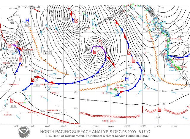
Nice! I felt like Bill Murray in Groundhog Day. Ironically the root cause of our cold wind was the same weather pattern sending giant surf of "historical proportions" Maui's way. Here's a look at the pacific weather map from that particular moment in weather history.
Note the two huge low pressure systems both with hurricane force winds. The fetch produced by these two systems looks like it stretched from the north pole almost all the way to HI. And this was reinenforcing waves that were already at high levels from a previous big storm. At the same time these two systems created an east to west pressure gradient that runs all the way to the west coast and Oregon. This was drawing artic air from Canada that was being sucked through the columbia river gorge. Which is why we were freezing cold while Maui was being pounded by giant waves.
Here's a video of Jaws on Dec 8th showing some of the action...
Also check out this slide show
Finally let's see what Pat Caldwell was saying in his surf forecast...
December 4 is the 40 year anniversary of the largest surf episode of the last 50 years which occurred in 1969. Coincidentally, a similar pattern is brewing this year. Extreme episodes in February 1986 come to mind as well. For those and the present case, there were pairs of giant episodes a few days apart, with the latter larger. This is because the followup systems act upon existing seas and swell, increasing the wave growth potential...
Both the 1969 and the present case had the second system of the pair just south of Japan that was tropically fueled, that is the remnant of a western Pacific typhoon. Moisture from the remnant of typhoon nadi was fed into a developing extratropical cyclone on Thursday. The track of 1969 and the present are very similar, moving east along 40°N. Models show the present system occluding around 170°W on Saturday, with an exceptionally broad fetch of storm to hurricane-force winds nosing to within 1000 nm of Hawaii on late Saturday. The difference with the 1969 case is that the track of the 1969 center moved further east than the expected track of the present case, to 157°W before drifting NE. The present case is modelled to drift slowly N at around 163°W. However, models predict the center of the present low pressure below 950 mb, deeper than the 1969 case. In any regards, both systems became occluded, with a slow decrease in surface winds speeds, exceptionally broad fetches, and proximity to Hawaii to make an extended period of giant surf.
I like that - sounds a bit ominous. However it's worth noting that the Dec 7-8 swell was giant but as it turned out not the largest swell in 40 years. The biggest swell from the double lows passed just east of the islands (someone else got pounded). However there was no lack of giant waves this winter in Maui. There have been about a dozen high surf events since we left. Unfortunately for most of the past three months there was little wind. Well, we just got back last Thursday, Feb 25th and there has been nothing but wind since. Yeah we brought it back! Plus we just had a huge huge day at lowers on Tuesday, when the last big swell turned North and delivered some 25ft + sets.
The only picture I have of our return so far is a picture from Maui News. If you look closely you will see Julia in the background.
And finally finally it seems the west side has also been epic. So we're back! Aloha - jamin
Windsurfing, surfing, Maui, The Gorge, and random rants.
Thursday, March 4, 2010
Blog Rebooted - Recap of Winter in HR and the Historical Surf
Posted by
(Ben) Jamin Jones
at
9:31 PM
Email ThisBlogThis!Share to XShare to FacebookShare to Pinterest

Subscribe to:
Post Comments (Atom)


1 comment:
Just found your blog off of GP's...very cool.
Keep up the great work.
Mahalo,
JM
Rkfd. IL
Post a Comment