Windsurfing, surfing, Maui, The Gorge, and random rants.

Saturday, October 30, 2010

Big Surf Boys and Girls Get Yer Engines Ready

I mentioned and showed a weather model in my last post that predicted a large storm was forecast to spin up in the North Pacific. And now that prediction has come to pass. Here's the actual weather map for today...


Note this giant storm has the name "hurricane force".  A very unimaginative name that.  How come all the tropical hurricanes get nice easy to remember name, like "Earl", while these giant northern pacific storms that produce bigger surf, have hurricane force winds, and impact a greater area get squat?  I mean look at the size of that storm!  The pressure gradient lines (or wind contours if you prefer) circle this gyre from the interior of Kamchatka to the coast of British Columbia, while the northern fetch brushes the north slope of Alaska (about the arctic circle) and the southern edge is near 35 deg.

So let's try to estimate the total square miles of this storm's weather influence.  It appears to cover about 60 deg of longitude and 35 deg of latitude.  There is about 69 miles per degree of latitude, which means this storm is 2415 miles "tall".  Miles per degrees of longitude vary depending on whether you near the equator (60 miles) or the poles (0!).  Which makes this an inexact science, so I'm only going to use the height as the diameter (assuming a near circular storm) and give it the old circle area formula of pi*r^2.  I plugged this into my handy calculator (the radius is rounded to 1200) and got 4,523,893.42 square miles.  Lets just call that 4.5 million square miles of the earth's surface over which this unnamed storm is causing the winds to veer.  Now to put that in perspective, the entire continental US  is only 3.5 million square miles.  So this storm we don't even bother to name is almost 30% bigger then the entire US.  Imagine a storm centered on the US that covers it entirely, form coast to coast and from Mexico to Canada.  I'd bet we'd give it a name then! (and probably something like "The MF!").

Now I believe we should correct this injustice and give this storm a name. Considering it's largeness, I thought the name "Big Mama Jama" (assuming we use a female name) would be appropriate.  So BMJ is in the process of stirring up some rather large waves.  This is what our friend Pat Caldwell of the NWS has to say about it.

Hurricane-force winds are expected near the center, to 75 knots. The brunt of this modelled swell is aimed at targets NE of Hawaii. Over a wider area severe gale to storm-force winds are modelled to stretch from near Kamchatka to well east of the dateline, covering a fetch over 1000 nm long. Models show a long duration to the fetch. These aspects are the essential ingredients for creating exceptionally high long period swell. The nose of gales with seas to 30 feet is expected to reach to 1000 nm of Hawaii by late Sunday. Proximity of high seas is one of the important sources for winter-caliber surf in Hawaii. More explicit expectations can be provided after the pattern unfolds and estimates of surface level winds and seas are available. In any regards, consistency among models and model runs over the past 72 hours give credence to this event.

The local surf is expected to ramp up rapidly around sundown on Monday from 320-350 degrees. The episode is expected to peak mid day on Tuesday in the extra-large to marginally giant category, meaning significant breakers on outer reefs.

And here's the estimated wave height tables...

FORECAST
DATE
SWL
HGT
DMNT
DIR
DMNT
PD
H
1/3
H
1/10
HGT
TEND

PROB
WIND
SPD
WIND
DIR
SPD
TEND
1PM
10/29
8NE968SAME17-21ENESAME
2S1423SAME
SAT
10/30
5NE835DOWNMED11-16EDOWN
2S1323SAMELOW
SUN
10/31
2NNW1424UPLOW7-10EDOWN
3NNE1234DOWNLOW
2S1323SAMELOW
MON
11/01
3NNW1446SAMELOW7-10EUP
6NNW201216UPLOW
2S1323SAMELOW
TUE
11/02
14NNW173240UPLOW17-21NEUP
2S1223DOWNLOW
WED
11/03
13NNW142632DOWNLOW17-21NESAME
7NE846UPLOW

I highlighted the day of interest, which will be Tuesday.  We stopped by the Quattro shop and saw Keith Teboul getting a tow in board ready for action.  It's entirely possible that Jaws will be firing.  Whatever happens I plan to be there with my camera.  I haven't see Jaws yet in person and I'm looking forward to that if it does indeed happen.  Last year we left just a few days before the first giant surf day and the first possible Jaws day of the season (as I mentioned here).  This time I plan to be there.

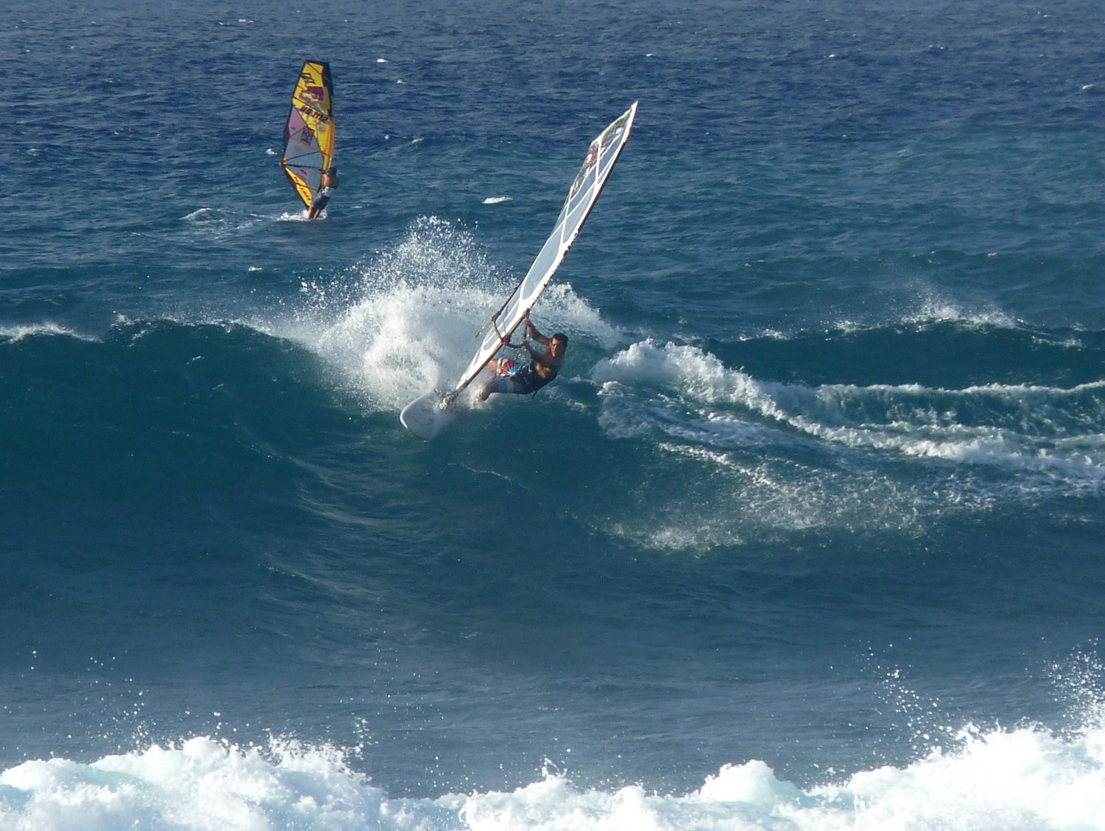
And now a  few more random things.  We've had some fun days windsurfing both Lowers and Uppers recently, with a small to moderate swell at times kicking up head high waves.  Perfect for practicing those bottom turns and off the lips!  However the influence of BMJ is about to be felt (even here a mere 20 degrees from the equator) and the trades winds are predicted to go into hiding for several days, possibly until Wednesday.  So big day Tuesday (or whatever we will call it, maybe BMJ Tuesday) is likely to be windless.  Which is fine by me as I'd rather be checking out the big surf action.  Also it looks like the large surf is going to be hanging around for the rest of the week.  Not giant mind you, but plenty big.

The Nelscott Reef big surf contest off the Oregon Coast is on for this Tuesday and BMJ will be throwing them the biggest waves they've ever had.

And it's interesting that this La Nina winter, which is normally expected to have few if any giant surf days, has now sent one our way so early in the season.  The pattern so far seems to be this - a week or so of wind with small to moderate waves, and then a significant swell with perhaps a few days of light wind.  First there was a decent swell at the end of September (and early for the big size), then another one ten days ago, and now this.  Plus we've had pretty consistent wind, with windsurfing on 24 out of 30 possible days so far this month.  La Nina years usually have stronger (and occasionally wetter) trades and so far that part of the pattern is holding true.  Sounds good to me - if this holds we should have a nice combination of waves and wind throughout the winter. Last year there was very little wind between December and February but many (many!) days of large surf.  So hopefully things will be a bit better mixed this year.

Finally (and note this is a work in progress) I put together a page that shows the future weather models.   This is still in "beta" and right now I need to update the internal links manually, but eventually I hope to have this automatically show the next 7 days of weather maps along with the forecast swell heights and direction.  Cheers!

Tuesday, October 26, 2010

Another November To Remember?

Last year we stayed for the entire month of November and experienced an awesome combination of early winter swells and mostly consistent (and not too strong) trades. This was of course a prelude to a winter season that produced some of the biggest waves seen in many years (perhaps 30). It also happened to be an El Nino year. But there was a downside to that, at least from the windsurfing perspective - there was virtually no wind from early December until mid February. But this was a very good thing for most everyone else on the island, especially Jaws photographers and big wave surfers. Actually there was another downside - the lack of trades for most of the winter resulted in a very dry year and we can see that impact in all the brown vegetation on Maui. A lot of the grass at Kanaha has turned to sand in fact. Hopefully we'll get enough trades and rain this winter to bring back some grass and green things up.

So this year has the exact opposite pattern - instead of the naughty little boy we get La Nina (his twisted sister). Such sister years typically feature high pressure cells which dominate the north central pacific. These mountains of air leave little room for the deep storm systems needed to produce our giant waves. Meaning that, unlike last winter with a seemingly endless parade of high surf warnings and Jaws breaking weekly, big wave days could become infrequent guests. And this past October has fit the La Nina pattern so far. Actually there was a decent swell at the end of September (which we just missed), and from then until last week there wasn't much for waves. Over the past couple days we had another small NW bump (and some fun at lowers), but for the rest of this week (and in fact the rest of the month) it looks extremely windy with only wind swell and chop. Plus a few small NW bumps here and there but nothing very exciting.

This brings up the subject of which month is the best month for a windsurfer to visit Maui. I'd say any month can be fine, but windsurfers want trade winds blowing a decent % of the time, so this rules out the winter months (December and January). February, March and November trend toward more waves, with the potential for really big surf, but also with a decent chance of skunk-age. To me that's a reasonable trade off if you can spend an entire month here, but for shorter stays there is too big risk of nada wind. (though the newer wave boards work so well in light wind that this is not as big an issue). Also if you have any inclination for other water activities (such as surfing) then the extra chance for decent waves makes these months a good bet IMO.

But for most folks, it seems that October and April offer the best chance for some waves and decent wind. That's the reason we (and the board testers) would usually pick our two week Maui trip during these transitional months. Though I should mention that some years we got skunked at least one week anyway, so there's no guarantees - be ready to surf or simply enjoy the beach on your vacation (no so bad). Now up until last November, I didn't realize that we had never experienced any "real waves" during these shorter October/April trips. And I know that it's pretty rare for these months to have anything more then a moderate swell, though again for many people that's all they need.

I should also mention that it blows hard almost every day during the summer months, May-September. Almost too hard in fact, and there's very little chance for real waves (though south coast surfing can be had). But if you want guaranteed wind and lots of it, a trip in the middle of summer is for you.

Anyway, last year we were here for our first November, and it was awesome (see my older post about that). Easily the best conditions we had experienced here until, well last March, which was even more awesome (bigger waves and more consistent wind in fact). And now another November is fast approaching.  Considering the La Nina forecast, would it be too much to ask for anything close to last year's conditions?  With that in mind I spun up the GFS/NOGAPS weather model to show next week's north Pacific maps.  And here's what I got for Nov 1...


That's one giant bomb of a low pressure system spinning up just south of Alaska, with a fetch reaching from the Bering Straits to nearly 30 deg south and aiming pretty close to our tropical islands.  It's too far away to make wave height guesses, but something significant looks pretty likely next week - the first week in November.  Yeah!

OK, lots of words and few pictures so far.  And I really like pictures, so lets throw in a few.  Last evening, on the tail end of the daily "commute", we spied the sun setting behind the West Maui mountains, and pulled off the Haleakala highway to take a few shots.  Be sure to maximize and play as a slide.  Enjoy!

Thursday, October 21, 2010

First October Swell

As widely anticipated, the first swell in about a month showed up yesterday. Julia and I stopped by Hookipa to check it out and take some pictures. Around noon the wind was light to non-existent and the swell was still building. This came after a period of slack waves and wind for a few days, so the water at first was very glassy and smooth between the sets. This swell originated from a storm up near the Aleutians so the period was fairly long (15 secs). The created some very clean conditions as the swell was building. We started at the lookout taking shots of the surfers on the east (pavilions) side. A few really stood out (if anyone knows names please add to comments, thanks!)


Next we wandered over to the bluff (west side) and took photos of the surfers on that side. Out there we spotted Keith Teboul on one of his custom Quattro boards.  Keith surfs as well as he windsurfs - very impressive.


At this point the wind was gradually building, though it never got much above 20 and was always near zero on the inside.


By 2pm a few kiters launched from Lanes and started shredding the (now much larger) waves down there.  Guessing the max face heights around 12 ft on the larger sets at this point.  Note to kiters - you guys have it so easy when it comes to getting over large waves!  Just a quick boost needed to jump over the double head high sets.  So if that's too easy for you... try windsurfing!


Next Josh Angulo ventured out (with much slogging on the inside), quickly followed by Kai Lenny and Ricardo Campello.


And soon by the rest of the Hookipa windsurf tribe...


With the wind now getting lighter and the waves still building (sets to 15ft by now), inevitably there was carnage, with broken gear washing up on the rocks.  No damaged bodies though, so that's good.


Those still on the water played on.


Showing up very late, as the wind was pretty much nil, was Francisco Goya.  Watching him schlog out, barely making it over the now huge waves (and almost ending up in Lanes) and then still catching waves and getting back in one piece was amazing.  It probably helps to have a very pretty (and strong) sail!


Kai Lenny, after windsurfing for hours, didn't get enough of a workout. So he went back out on his SUP and showed why he's #1 in the world.


Eventually, as the sun started to set, the water was left to the remaining surfers and the large surf.


It was awesome to see all the water sports represented out there (with a few individuals doing multiple activities).  All of us love the water and the waves, each in our own way.  Lets maintain the respect and the passion for these sports, including those sports we might not necessarily participate in. It's important that an incredible spot like Hookipa can be shared in this way.  I saw very few conflicts out there.  I watched Francisco on several occasions jibed away from waves to let surfers take them.  At one point Keith Teboul was surfing while his windsurfing buddies were on the next wave.  Stoke, respect, passion.  Mahalo!
Copyright © 2011 Jamin Jones, All rights reserved.