Windsurfing, surfing, Maui, The Gorge, and random rants.

Monday, November 30, 2009

Long Swim at Lowers, Helped by a Kiter, Huge Waves are Coming!

The forecast called for north waves 12-16 ft with gusty NE trades in the 20-30 range.  So when we got to Kanaha we were very disappointed to see the wind was not at the advertised speed.  In fact it was light and onshore - NNE (30 deg) at about 15mph or so (though Kihei was trying to make up for this by blowing 30-40 - thanks a bunch!) .  Here's the day's iWindsurf graph for Kanaha to better illustrate our situation..


We patiently waited in the parking lot for the wind to come up.   Nick Warmuth actually didn't need no stinkin wind - he slogged out on his 5.3 and OES 75 lt board.  And by slogged I mean board completely under water, no chance  of planing, SLOG!  We watched in amazement as he slowly worked his way up to weird wave, caught a little ride upwind, and eventually got to upper's outer reef where he promptly started catching big rides. Well that's Nick for you. The only other person out was Sven Zedlick on a 7.0 and a 115 lt slalom-ish board.  He wasn't slogging but no one else has gear like that.

[ BTW - Sven's son Bjourne is intervied in the latest November 2009 Windsurfer International Magazine - see the Future Forms feature.  Or just check out the entire issue, great stuff as usual.]

Now where was I?  We waited to about 2:30ish when the wind came up a bit.  I rigged my biggest kit, a 5.3 Ice North Sail on a 90lt Goya custom wave.  This board is sweet on a wave but is not an early planing machine.  Now I should mention that this board is a 2007 model and I have taken the latest 2010 Goya 89 twinzer out for a spin (see pic on right), and that board is IMO improved in many ways.  It seems to plane sooner, stick on the waves a bit better, never spun out on me or did anything weird, and it was fine for doing what little tricks I can do (fwd loops, heli tacks, etc).  I wanted to be on that again, but today I was back on the 2007 and a very underpowered.  I slogged out anyway to see what the waves had.

And they were big, much bigger then I thought.  Seems that the white water on the inside was big enough to make the waves outside look not so big from the beach, but on closer inspection the channel between lowers and uppers was often closing out with a 10ft + wave, and lowers itself was throwing down something that looked 16ft or maybe even 20ft at times.

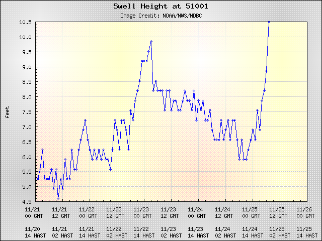
And these waves were different then the usual lowers waves.  They seemed to have more force.  Maybe it was the size, maybe it was the direction, or the combination of swells, maybe it was the full moon and rising tide, or maybe just the fact that the wind was so onshore.  Either way I noticed a few things 1) the inside breakers tended to pitch harder and slow me down more then usual 2) there was almost no wind in the impact zone (onshore wind again) 3) there was a lot of current 4) the swell was pretty big.  Let's turn to the Waimea buoy to see if this is imagined or not...


Note the sudden rise of a 12 ft 12 sec NW swell right in the middle of the day.  Another N swell was hanging around 10ft and looks like it bounced down and back up again.  Not sure if this is exactly what we experienced on the water but a 12ft swell at 12 secs is likely to produce something close to 20 ft waves, and who knows what that other swell was doing out there. 

I continued my slog out through the channel and caught a decent mid sized wave back in.  I was only really moving when on the wave.  I tried to get back out through the break and was rejected not once but twice. At this point I noticed that the life guard was buzzing around on his jet ski keeping an eye on me (and others I presume) as I barely water started and headed away from the waves.  This time I went back out through the channel (with some wave take downs to make it interesting) and then caught a nice sized wave.  Managed a decent bottom and top turn or two and then rode up the line back to the channel.  Feeling good about that, I headed back to the outside.  This time I noticed that Julia had joined me (see pic).

Barely moving this time I made it to the outside, just as a really big swell passed under us.  I could see a large wave closing out the channel up to weird wave, and watched the swell that just passed rise up and throw down what looked like a 20 footer and a wall of spray on the inside.  This was followed by three or four equally large swells. We both did slog jibes though Julia was a bit more powered up and passed me headed in.  I was hoping to catch a larger wave this time, considering the swells we just saw.  But I was really slogging and as I got closer in I was nervous that a large set would break outside and catch me in the dead zone.  I tried to catch a medium-ish wave but had no juice at all.  Julia manged to get on this and I saw her ride up the line into the channel.  I was still slogging bad, there was really no wind in here!  I looked over my shoulder and sure nuf, there was a huge wave pitching up behind me, rising about 18-20 ft or so, and looking to break about  on my  head.  I pumped hard and the wave broke just behind me. For a second or two I thought I could stay in front of the white water which was over my head but it out ran me and next thing I knew I was tumbling trying to hold on to my rig.  Which was then almost instantly ripped out of my hand.  I continued to tumble and when I came up I barely had time to catch a breath before the next wave was on me.

This continued for three or four more waves and by the end I didn't care where my rig was, I only wanted to get out of the white water and survive this.  I wasn't trying to swim as much as just relax and catch my breath.  This was my first experience with 1) really losing  my gear (I rarely let go and if I do I'm usually not too  far away), 2) being in breaking waves large enough to leave me short of breath 3) feeling a wee bit of anxiety as I considered where my gear might be.  I floated on my back and rode the inside break until the waves were no longer thrashing me.  Then I looked for my gear and it was a long, long ways away.  The wave first caught me almost at the channel and now I could see my gear was about down to kite beach.  I wasn't even sure if it was mine - just assumed based on that it was the only rig in the water I could see.  I stated swimming but I was still sucking wind from the beating I just took.  Didn't take long before I realized that I was not closing the gap at all.

There were a few windsurfers around but they really didn't look at me. Honestly there wasn't much they could do.  There were also a bunch of kiters and I waved at one dude and he dropped next do me.  I asked for a lift to my gear and he said no prob!  I grabbed his harness handle (which now seems pretty convienent to have) and held onto his directional board as he basically body dragged me down to my gear in what seemed like 30 secs.  Sweet!  About this time the life guard circled back and I gave him the thumbs up and got going.  Kiter dude - whoever you are - thanks much for the lift and hopefully you will get some good karma for that.  As for me, I'm going to smile at every kiter I see for a long time.

After that the wind seemed to have come up a bit but I was in no mood for more beatings, so I headed upwind staying on the inside working on tacks until I got back to our usual location (upper parking lot).

So an interesing day.  Hopefully not the last wave sailing day for us but we are scheduled for departure on Friday and right now the forecast looks light for wind.  However there will be waves, lots of waves.  Here's the last part of Pat Caldwell latest surf forecast ...

In the northern hemisphere, models show the Aleutian low from the surface to the jet stream forming a huge gyre centered just east of the dateline starting this weekend. A broad area of severe gale to hurricane force winds to within 1000 nm of Hawaii should equate to giant surf locally starting around Sunday night, lasting several days from 300-340 degrees. Local winds to vary day to day from around the compass.

And the rumors have already started that HI could be getting one of the biggest swells in many years from this.  In fact Pat made mention of the famous Dec 4th, 1969 storm 40 years ago that up until now is known for creating the largest swell in modern times.  This swell also helped to cement Greg Noll's fame. Watch the movie Riding Giants (2004) if you want more on that story.   What Pat said is basically the weather set up looks similar to then.

I'm curious what the models are actually showing for this period so I snuck a peek.  Check out the giant storm predicted for Sunday 6th December with a fetch from Siberia almost all the way to HI.  Wow!


Saturday, November 28, 2009

Harness Left at Kanaha on 1/28

We now interrupt the usual stream of pointless drivel for a public service announcement.

[ Update - the mast has been claimed,  We still have a lady's (we think) harness looking  for its owner. ]

FOUND : at Kanaha on Saturday (11/28) a mast and a harness (not together).

If either one is yours please leave a comment here. Describe it and it is yours! Also we're going to be at Kanaha on the east side of the parking lot so you can track us down there (ask for Ben & Julia).

Friday, November 27, 2009

Jaws went off - and may again soon

So Jaws in fact did "go off" in a pretty good fashion on Wednesday.  We had driven up to Haiku and heard early reports that it "wasn't that big".  But I guess not that big is all very relative , right? Maybe not 60ft but it looks like it hit around 45ft on the bigger sets.  To me that seems plenty big enough.  We're sort of kicking ourselves for not driving down there, but we also heard that non-4WD drive cars might not make it.  Again this wasn't entirely true. The access road was in pretty good shape, though I suppose in the winter with enough rain this could be a very different situation.

Fortunately some folks did make the drive and got some great shots of the action.  The first picture is from Nayra's blog and shows Francisco Porcella skipping down the face of a huge wave which then sucked him up and through him over the falls.

Francisco Porcella wishing he had a "Jaws" board.


Tormod's blog has an interview with Francisco Porcella concerning his Jaws experience and its very entertaining. The amazing thing is that Francisco stayed out there and after the wind came up he rode Jaws again, this time windsurfing.

The sail is 15ft high so the wave is ... 45ft?


Again check out those blogs for more pictures and stories. Now I've been reading the surf forecasts a lot lately and its nothing but swell after swell, even on the south shore! Here's some snippets to give you an idea...

Outlook through Thursday Dec 3: ... surf is expected to build on Saturday morning, peaking in the moderate to marginally high bracket late Saturday. Moderate surf from 320-350 degrees should hold on Sunday... more marginally high surf locally building Sunday night and holding on Monday. Surf should lean below moderate levels by Tuesday afternoon... a new episode locally, with a slow rise due to the long travel distance starting on Wednesday morning from 315-325 degrees, reaching the high category late Wednesday...a storm-force system SE of New Zealand on Thanksgiving into Friday has generated seas over 30 feet, as validated by the jason altimeter. This could give a moderate to near high episode starting next Friday into Saturday from 185-200 degrees.

And if all that wasn't enough, check out this last paragraph in Pat's surf forecast:

In the northern hemisphere, it will be the 40th anniversary next week of the hugest surf of the last 50 years, a series of episodes with the peak day on December 4, 1969. That episode was a typhoon-fueled, extratropical source. Presently, there is a typhoon in the western Pacific, nadi, to watch for re-curvature into the central north Pacific mid next week. It is too early for specifics, though the potential for the gender bender, meaning a tropical warm core low turning to a mid latitude cold core low, ups the surf potential ante.

To be sure, look at the NPAC map below and you will see Nadi, currently a super typoon with winds of 150-180kts, in the western pacific in a location favorable for gender bender potential. We probably won't be here for this swell event if it should happen, though tickets can be changed...


Turkey Day Feast Maui Style

For our our first Thanksgiving in Maui (Turkey Day) we had dinner with some of our new friends up in Kula. This house had stunning views, artwork, food, and it was generally a festive occasion for all. Pictures below. Cheers!

The sun was slowing setting
Almost gone
Julia looking glamorous
The view from Jeff's Kula house looking west
Jeff had some very nice art - Hookipa
Waves on the beach
Textured wall sculpture
The view from the table
Table before food
The feast is served
Our awesome host - Jeff!
My plate - yummy!
Desert - pecan pie, apple pie and of course pumpkin pie
Debbie the photographer
Me and my girls
Francine showed us her famous cork blowing technique - how does it stay up there?
After dinner Jeff and girls entertained us
The piano man
Then Deb and Garth had to dance
Debra as ballerina
We danced until the dogs ran home

Wednesday, November 25, 2009

The Big Wave Day Finally Arrives

NWS had been predicting some giant surf on Wednesday for many days, 20-30ft with higher surf possible at "select outer reefs". We got scattered reports that Jaws was in fact breaking but mostly around 25ft (but see update below). Originally we thought about checking out the action there but we weren't sure if our little mini-van could make it down the pineapple access road (reports said it was drive-able but definately sketchy after the afternoon rain). The direction of this swell, 330 degs, might have caused some energy to be blocked by the smaller islands NW of Maui (at least for Hookipa and points west). Also the swell did not have the most optimal period. It was around 16 secs at the peak in the early morning and then dropped to around 13 secs by the evening. Which made the surf a bit chaotic and closing out at least later in the day. No surfers at Hookipa and definately no windsurfers - the lack of wind took care of that (except for very late in the day at Kanaha).

Anyway, the surf was still pretty impressive from Hookipa. We took some pictures around noon with my tiny camera (very tiny compared to some of the huge-mongo cameras out on the bluff). You can get a pretty good idea what the surf was like from these shots - click each tab below for a view.

[ Update: I got reports today that Jaws was firing at around 40+ ft at the peak of the swell. Tow-in surfers were on it in the morning. In the late afternoon the wind came up and some windsurfers gave it a go. Not sure if that worked but Kanaha was apparantly fun in the late evening as well. ]

Enjoy!

Sunday, November 22, 2009

A November to Remember - So Far

[ Note - I'm going to update this post with the forecasts as this giant wave event unfolds for each day. See the tabs below ... ]

Our first November on Maui has turned in some of the best wave sailing conditions either of us have seen in our fairly short Maui experience. Usually we only stayed for one month - October - and left more or less around Nov 1. We would also often come in the spring for a month or so, usually around April. However it has become apparent that one can work very productively from about anywhere these days - thanks to the ubiquitous spread of high-speed internet combined with tools (GotoMeeting, VOIP, IM, VPN) and the good fortune to work for a company that allows such a flexible work environment. Which I believe is a benefit to both parties (perhaps more on that in a later post).

So where was I? In previous years it always seemed that conditions around Nov 1 were looking pretty good just as we were jumping on the plane back to (usually) rainy cold Hood River. Sure, the winter swell should be picking up in general, but you never know about trade winds as you get into the winter months here. But lucky for us November, this year at least, has had plenty of both (note we've sailed 19/23 days so far - biggest sail 5.3).

Now we're looking at a week of solid wind and waves, including huge (25 ft+) wave potential for Wednesday.  Click the tabs below to see how the forecast and conditions progess with each day.

Conditions on the water..

We sailed lowers at Kanaha, 5.3 for me and 4.7 for Julia.  Wind was sketchy in the morning but filled in nicely by around 1.  The waves were around 10-12 ft with occasional mast high sets, more as less as predicted.  The long period made the waves easy to see and ride. Very nice!

SURF ZONE FORECAST
NATIONAL WEATHER SERVICE HONOLULU HI
900 AM HST SUN NOV 22 2009

HIGH SURF ADVISORY NORTH FACING SHORES

  • Surf along north facing shores will rise to heights of 12 to 16 feet today and 14 to 18 feet Monday
  • Outlook through Saturday Nov 28: this forecast period includes a series of  large northwest swells.
The above normal northwest swell will likely remain at advisory levels through Monday, before slowly diminishing Tuesday. This swell is expected to be reinforced by a larger northwest swell early Wednesday morning with the potential for the surf to top at or near warning levels for the north and west shores. This will be followed by a smaller northwest swell with advisory potential over the weekend.

Area Forecast Discussion for Hawaii...

A high surf advisory is in effect for north and west Kauai and Niihau, as well as north shores of Oahu Molokai and Maui. Current high surf advisory runs through Monday night since the fetch area that generated the swell persisted when a second low prolonged the episode. Consequently there is the possibility the advisory may need to run through Tuesday. The buoy northwest of Kauai rose overnight and surf will continue to rise through the day with a peak expected on Monday.

The storm system moving into the central north Pacific today has 2 low centers that together provide an extra long fetch. This should produce a larger northwest swell arriving Tuesday night with the peak occurring Wednesday. Warning level surf reaching 25 feet on Wednesday is likely on north facing shores that have good exposure to this next northwest swell.

The wind outlook..

Over the north Pacific, the surface high far northeast will shift eastward and the surface ridge will move to almost 200 miles north of Honolulu Monday and Tuesday. Trade winds will decrease to moderate strength during this period. Models agree on moving a cold front toward Kauai Tuesday night but stalling it north of the islands Wednesday and Thursday. It appears the associated upper trough is not strong enough to push the front down across the main Hawaiian islands. By Wednesday a new surface high moves in behind the front and trade winds are strengthened.

Also of note is the NW bouy showing the incoming NW swell at 17 secs and growing...


Finally a look at the NPAC map shows the source for the next big swell developing. Note the Hurricane Force text by the low north of HI.


Conditions on the water..

Again we sailed lowers and again the wind was very light from 11 to about 1-ish. Early reports of very gusty and "technical" conditions. Some guys were on 5.3-5.7. I had a choice of a 5.0 or 4.7 to rig (my 5.3 needs some fixing) and I delayed until the wind filled in, so finally headed to lowers on a 4.7. Very light on the inside but the wind was solid by the break and lit on the outside. The waves were a bit down from Sunday though the bigger sets were still probably mast high-ish (12-15 ft). Only complaint was the strong wind kicked up a lot of chop. Plus it was a bit crowded with lots of people in the water swimming for gear, which made some of the wave rides a bit more challenging.

SURF ZONE FORECAST
NATIONAL WEATHER SERVICE HONOLULU HI
900 AM HST MON NOV 23 2009

HIGH SURF ADVISORY NORTH FACING SHORES

  • Surf along north facing shores will be 10 to 14 feet lowering to 8 to 12 feet later tonight and Tuesday.
  • Outlook through Saturday Nov 28: this forecast period includes a series of above normal northwest swells.
The current northwest swell will start lowering later today. This swell will be boosted significantly higher Wednesday by a new northwest swell. This new swell has the potential for high surf warning for the north facing shores and high surf advisory for the west shores. A smaller reinforcing northwest swell is still on tap for this weekend. The size of this swell is similar to the current one. On Monday, a north northwest swell is on tap to keep the advisory level surf going along the island' s north facing shores.

Area Forecast Discussion for Hawaii...

No changes were made to the high surf advisory. Surf will remain solid into Tuesday, but should drop below advisory levels by then. The surf along north facing beaches' reefs will begin to increase abruptly again Tuesday night potentially requiring a high surf warning for waves exceeding 25 feet on the face by Wednesday with a slow decrease to follow thereafter. It is not out of the question for advisory level surf to persist through the remainder of the week along north facing shores.

South facing shores will see continued waist to shoulder high southern hemi swell today. A decreasing trend will begin Monday night through mid week. Modest southeast swell will appear during the second half of the week possibly hitting the chest high mark along the better exposed reefs' beaches.

The wind outlook...

Trades will weaken slightly during the first half of the week as high pressure to our northeast is displaced further east by an amplifying deep layered trough to the north. Mid latitude flow will remain progressive ushering in height rises and surface high pressure to our north again by mid week allowing trade winds to strengthen once again. This will also limit the equatorward reach of any attendant frontal activity. Regardless of fluctuating batches of moisture passing in the trades the weather will remain pleasant through the forecast period.

The NW bouy showing the current NW swell peaked early Monday on Maui


The NPAC map with a Hurricane Force low north of the islands.

Conditions on the water..

Light wind today and fading but still decent swell from the earlier episode.  We made it out on 5/3/4.7 to lowers.  Lots of slogging between waves but no crowds!  I was able to demo a 2010 Goya 89 lt twin fin wave board which made the conditions much more fun then they should have been.

Now for a late day update on the incoming giant surf.  Buoy 51001 (NW of HI) is showing a rapid increase in the size of the forerunners from this new swell.  Check out this real time graph...


Below is the forecast from this morning but the details remain mostly the same .. huge waves!
SURF ZONE FORECAST
NATIONAL WEATHER SERVICE HONOLULU HI
900 AM HST TUE NOV 24 2009

  • Surf along north facing shores will be 6 to 10 feet today, building to 25 to 30 feet Wednesday.
  • Outlook through Monday Nov 30: the large northwest swell will peak on Wednesday, and slowly lower through the end of the week. Surf is expected to drop below advisory levels late Thursday night. A new northwest swell will arrive by Saturday night, and bring surf back to near advisory levels

This is taken from Pat Caldwell's commentry...

The jet stream track shifted southward late last week over the northwestern to central north Pacific. Models show a winter-type pattern this week into next with overlapping high episodes.

An extratropical cyclone tracked from Kamchatka east along the Aleutians last Friday into Saturday with severe gales in the 325-335 degree band. This source alone would only result in moderate surf locally, yet a followup system has acted upon the existing seas from the former system.

Another low pressure formed off the Kuril Islands on Saturday, with a amplifying jet stream trough steering the system slightly south of east. Storm-force winds centered on 320 degrees relative to Hawaii set up from Saturday into Monday, with a resultant captured fetch due to the system traveling at speeds similar to the growing seas. On Sunday night, quikscat showed severe gales to near 1000 nm from Hawaii in the 315-330 degree band. Combined with the other Aleutian source, and considering the proximity to Hawaii, this spells extra-large to giant surf for northern shores of Oahu. Models show the system racing to the NE into the gulf of Alaska over the next 24 hours, turning off the source from 315-330 degrees.

One aspect of a relatively nearby source is typically a rapid rise, which is expected in the wee hours on Wednesday. Surf should be well into the high category at dawn, with the episode peaking mid day from 310-330 degrees. Heights in the table above refer to peak face at the moment of maximum cresting in zones of highest refraction. Waves break in water depths similar to wave heights, thus these type episodes result in highest breakers on outer reefs in deeper waters. Surf heights at highest near shore spots are usually about 30% lower.

The episode should remain extra-large, meaning significant breakers on outer reefs, into the holiday, and fall off steadily on Friday as the direction broadens from 315-360 degrees. The amount of swell from 340-360 degrees should be moderate or less since the system is expected to be over that directional swath relative to Hawaii for less than a day.
....
In the northern hemisphere, back-to-back episodes into the high bracket are expected next week with about a 3 day spacing between episode arrival. Trades most days with peak days in the fresh to strong range.

FORECAST
DATE
SWL
HGT
DMNT
DIR
DMNT
PD
H
1/3
H
1/10
HGT
TEND

PROB
WIND
SPD
WIND
DIR
SPD
TEND
WED
11/25
14
NW
16
30
38
UP
HIGH
17-21
ENE
UP
7
ENE
8
4
6
UP
LOW
2
SSW
12
2
4
DOWN
LOW
THU
11/26
11
NNW
14
20
26
DOWN
MED
17-21
ENE
SAME
8
ENE
8
4
6
SAME
LOW
FRI
11/27
7
NNW
13
12
14
DOWN
MED
17-21
E
SAME
8
ENE
8
4
6
SAME
LOW
SAT
11/28
7
NNW
16
12
16
UP
LOW
17-21
E
SAME

Area Forecast Discussion for Hawaii...

A complex storm system moving across the northern Pacific ocean has aimed a new very large northwest swell toward the island chain. This large open ocean swell is expected to arrive in the islands tonight, with surf heights forecast to rise abruptly by late tonight and continuing through Wednesday. The forecast surf heights resulting from this swell will likely require a high surf warning along north and west facing shores of Kauai, Oahu, and Molokai, as well as north facing shores of Maui. Based on the forecast swell direction of 320 degrees, do not anticipate surf heights reaching the high surf advisory threshold along north or west facing shores of the Big Island due to shadowing by the smaller islands. A marine weather statement has been updated this morning with additional information about this swell and its potential impact on the waters adjacent to the Hawaiian islands. This northwest swell will slowly decrease after Wednesday, but surf heights will likely remain near or above the advisory threshold along north and west facing shores of the smaller islands through Thursday.

The wind outlook..

The trades will weaken to moderate speeds from late Friday through Saturday when the high moves off to the northeast. The trades will likely increase again by Sunday when yet another high passes by far to the north of the state
NW buoy shows the current NNW swell is very slowing fading but still at a decent 15 secs.


NPAC shows the hurricane force low is still throwing a fetch our way though moving further east.


Conditions on the water..

Ah yes, Wednesday, the big swell day! First off there was no windsurfing or surfing anywhere on the Maui North Shore that we could see. Windsurfing was shut down due to lack of wind. NWS had been calling for trades to build, but first we had a decipating front and a high buidling behind it. The wind finally did come up, but not until around 5ish. The good news is we're supposed to have trades for many more days now. As for the giant surf, well it did look really huge in the outer harbor (outside of lower kite beach), and we could see big breakers outside of Uppers at Kanaha, possibly 25ft +. Hookipa had some big sets as well. Plus Jaws was supposedly hitting (correction) 40ft (as predicted). But for most of the north shore it was just closing out. This swell had a period around 16 secs which came down to 13 secs or so, probably too short for waves of this size to be rideable at the usual breaks. At least from what we could see. I did take a bunch of wave pictures at Hookipa - check them out. Now on to the forcasts for the remaining days of this "big week".

SURF ZONE FORECAST
NATIONAL WEATHER SERVICE HONOLULU HI
700 PM HST WED NOV 25 2009

HIGH SURF WARNING FOR NORTH AND WEST FACING SHORES

  • Surf along north facing shores will be 15 to 25 feet lowering to 12 to 18 feet Thursday morning
  • Outlook through Tuesday Dec 1: surf is expected to drop below advisory levels Friday morning but a new north northwest swell will arrive Saturday, boosting surf back to near advisory levels.
The current large northwest swell continues. Swell data from buoy one located northwest of Kauai and Waimea bay buoy shows a subsiding trend. The data supports the continuation of the high surf warning for the rest of tonight for affected shores. Surf will continue lower through Friday.

Area Forecast Discussion for Hawaii...

...the breezy trade winds will also carry some of these showers downwind into the leeward communities from time to time. In other words, passing showers. Saturday looks good with the return of more typical trade wind showers.

The N buoy shows todays big swell ramped up very quickly early Wednesday, peaking around 16 ft with a 16 sec period.


The NPAC map shows yet another low tracking toward the Aleutians which should bring another high level surf event by Saturday.  Fun!

Conditions on the water..

This is the last report I'm going to post about this "big swell week". Looks like the wind and waves will more or less continue for several more days (and then we must leave)...

The big swell slowly came down but not before serving up another fun day on the water. Per usual this week, the wind was very light to nothing early on and we sat on the beach at Kanaha watching people slogging. I'm much better about slogging in waves then I used to be, but I have my limits. The trades were more NE - and Kihei was hitting 31 gusting to 44! - but we hung around until the wind came up enough to rig our largest sails - 5.3/4.7.
We slogged out to lowers to find a very nice 12ft ish wave which peaked near the channel upwind and then pealed with reasonable consistency down the line. The light wind made the slog through the break interesting / challenging but if we wanted it to be easy we would be kiting! (yes we windsurf for the challenge). But the wave rides were sweet. The wind came up toward the end of the day, and shortly after we did de-rigged in a frenzy and sped off to our next adventure - the turkey day feast!

SURF ZONE FORECAST
NATIONAL WEATHER SERVICE HONOLULU HI
700 PM HST THU NOV 26 2009

HIGH SURF ADVISORY NORTH FACING SHORES THROUGH EARLY FRIDAY MORNING
HIGH SURF ADVISORY FOR EAST FACING SHORES BEGINNING FRIDAY MORNING

  • Surf along north facing shores will lower to 10 to 12 feet Friday
  • Surf along east facing shores will rise to 6 to 8 feet early Friday
  • Outlook through Wednesday Dec 2: surf is expected to drop below advisory levels on the north shore Friday. But the north swell generated earlier this week may wrap around to affect east shores which may experience 8 foot advisory level surf Friday through Saturday. A new northwest swell will arrive early Saturday to boost surf back to near advisory levels along north facing shores.
Area Forecast Discussion for Hawaii...

Trade winds will continue through the rest of the week into the early part of next week....

The current large northwest swell has subsided enough such that the high surf warning for north and west facing shores of the northern islands is cancelled. Surf heights are still high enough to warrant an advisory for those areas instead. As the swell turns more north to northeast by Friday, it may produce advisory level surf heights for east facing shores of the northern islands.

The N buoy shows that the "giant swell" has come down to simply big size, while another N swell with a short period has added into the mix.


The NPAC map shows a steady parade of strong lows and highs marching across the pacific.  Thats what we want...


Copyright © 2011 Jamin Jones, All rights reserved.